Fort Pickens Aquatic Preserve
NEWS | RESOURCES | CALENDAR
Fort Pickens Aquatic Preserve includes 30,000 acres of outstanding coastal water, encompassing areas known as Big Lagoon, Perdido Key, Fort Pickens, the Intracoastal Waterway (ICW), through the Pensacola Pass and into the Santa Rosa Sound. The preserve’s southern boundary extends into the Gulf of America for 3 miles from the mean high water line from the southern boundary of the Gulf Island National Seashore for approximately 12 miles east to west.
Southwest Pensacola and Pensacola Naval Air Station are directly to the north of the preserve. Perdido Key is to the west and Pensacola Beach is to the east.
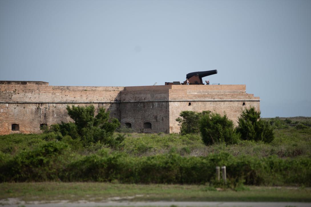
Fort Pickens is known for it’s historic forts and battlements, sugar white sand beaches, crystal clear waters and a diverse array of ecosystem types fostering many different species of coastal bird and marine life. This aquatic preserve is a popular place to spend the day fishing, camping at the state park, exploring bird trails, walking the boardwalks, bicycling along the Gulf Islands National Seashore, touring forts with family and learning about the underwater archaeological preserve.
Escambia, Santa Rosa
1970
30,000
Aquatic preserves, estuary, salt marsh, seagrass beds, beach dune, marine and estuarine unconsolidated substrate
Open 24/7 dependent on public access points, which are managed by other entities.
Boating, fishing, biking, kayaking, snorkeling, diving, swimming, wildlife viewing, nature photography, touring historical archaeological sites, Great Florida Birding and Wildlife Trail, Florida Maritime Heritage Trail, Florida Underwater Archaeological Preserve, Panhandle Shipwreck Trail
VISITATION INFORMATION
Fort Pickens is most easily accessed by boaters. The National Park Service has a ferry system to improve access to Gulf Islands National Seashore. The view from atop the numerous military batteries scattered across the barrier island, as well as the panorama from the top of Fort Pickens, offers the most picturesque scenes of the preserve. From these vantage points, one can see both the Gulf and the sound side of the aquatic preserve.
This preserve is also part of the Great Florida Birding and Wildlife Trail. The Pensacola Naval Air Station is visible from the scenic shores of Fort Pickens Aquatic Preserve and Gulf Islands National Seashore.
For very secluded experiences, visit the beaches on the western side of Fort Pickens Aquatic Preserve. Most of the area around this locale is accessible only via boat or on foot.
Parking
There are numerous public parking lots along Pensacola Beach. Parking along Perdido/Johnson’s Beach extends to a certain point, beyond which only foot traffic is permitted. Information regarding day use parking lots and access points can be found on the National Park Service website.
Boat Access/Ramps
- Gulf Breeze Shoreline Park South and Public Boat Ramp at 800 Shoreline Drive in Gulf Breeze
- Park West Canoe and Kayak Launch at 1400 Fort Pickens Road in Pensacola Beach
- Big Lagoon State Park Boat Ramp at 12301 Gulf Beach Highway in Pensacola
- Big Lagoon State Park Kayak Launch at 12301 Gulf Beach Highway in Pensacola
Facilities
There are numerous public use facilities, recreational areas and visitor centers to explore. All facilities are located within Fort Pickens Park, accessible by land from Fort Pickens Road. The Fort Pickens area has many activities and facilities available for visitors. Historic structures like Fort Pickens, Battery Cooper and Battery Worth are spread throughout the area. Tent and RV camping is available at the Fort Pickens campground, and several parking lots with beach access are located along the road after passing through the entrance station. For more information visit the National Parks Service website.
Contact
Paige Plier
850-471-6027
Paige.Plier@FloridaDEP.gov
HISTORY
Fort Pickens Aquatic Preserve was established on Nov. 2, 1970, by the Florida Board of Trustees for the primary purpose of protecting the area's biological resources and for maintaining these resources in an essentially natural condition. This aquatic preserve shares resources and some of the management with the National Park Service’s Gulf Islands National Seashore (GUIS). GUIS has received national and state recognition for its sugar white sand and crystal-clear waters, making it a favorable location for beachgoers from all over.
The sandy shores, seagrass beds, and estuaries in these waters are home to many species, several of which are endangered or threatened. All five of Florida’s sea turtles — Kemp’s ridley, hawksbill, loggerhead, leatherback and green — utilize Fort Pickens Aquatic Preserve. These sea turtles nest on the same beaches adjacent to Fort Pickens Aquatic Preserve, which are frequented by the threatened snowy plover. Additionally, the endangered Gulf sturgeon and the threatened West Indian manatee have been known to utilize Fort Pickens Aquatic Preserve.
This coastal area of Pensacola serves as the primary entry point into the bay, alongside the ICW that runs along the northern boundary of the aquatic preserve. The Pensacola Pass divides this aquatic preserve and provides passage for both commercial and recreational activities to the Gulf of America. Due to its proximity to the ICW, Pensacola Pass and Ship Channel, the aquatic preserve experiences heavy boat traffic.
Public Engagement Opportunities
Volunteer Opportunities
Volunteer opportunities at Fort Pickens Aquatic Preserve include assisting with marine debris cleanups and water quality monitoring.
Events
- National Estuaries Day
- International Coastal Cleanup
Educational Opportunities
- Fort Pickens Visitor Center (Discovery Center): Closed for renovations, reopening Fall 2025, located at 1400 Fort Pickens Road in Pensacola, Florida.
- Naval Live Oaks: Gulf Islands National Seashore Visitor Center, located at 1801 Gulf Breeze Parkway in Gulf Breeze, Florida.
- Guided tours of Fort Pickens: Tours are led by a park ranger and can be scheduled at the National Park Service website.

Conservation Efforts
Seagrass Restoration Project: Historical point source and nonpoint source pollution have degraded benthic conditions and resulted in a substantial loss of seagrasses within Fort Pickens Aquatic Preserve. Water temperature, salinity, wave-energy, tidal activity, available light and light penetration are all factors that influence establishment and growth in seagrass beds. This community is also extremely vulnerable to human impacts. Additionally, seagrass beds are susceptible to damage from anchors, trawling and prop scarring from boat propellers. Areas within the seagrass natural community in Fort Pickens Aquatic Preserve have undergone restoration and the current health and coverage will continue to be monitored and assessed. Future restoration projects will be implemented based upon areas of concern.
The Northwest Florida Aquatic Preserves office was awarded a prop scar restoration grant from National Oceanic and Atmospheric Administration (NOAA) through the Gulf of America Foundation, involving restoration efforts of the seagrass Halodule within the preserve in the eastern portion of Big Lagoon, adjacent to the national seashore. Educational signs are placed near these areas to protect grass flats, landmarks and restricted areas.
- Beach Dune Restoration: Beach dune systems hold sediment, which is crucial to Fort Pickens Aquatic Preserve in protecting submerged aquatic vegetation. Occasionally, beach dunes adjacent to the aquatic preserve are enhanced and restored to stabilize the shoreline and protect dune ecosystems. From 2009-2014, DEP restored, enhanced and diversified more than 11 acres of the beach ecosystem for dune diversity, stabilization, beach mouse habitat and research.

Project Greenshores
Project GreenShores is a multimillion dollar habitat restoration and creation project in downtown Pensacola along the urban shoreline of Pensacola Bay. This habitat restoration effort partners DEP's Northwest Florida Aquatic Preserves with the city of Pensacola, Escambia County, the Ecosystem Restoration Support Organization, the EPA Gulf of America Program, the National Fish and Wildlife Foundation, the U.S. Fish and Wildlife Service, NOAA, Gulf Power, local agencies, businesses and volunteers in a community-based effort to restore oyster reef, salt marsh and seagrass habitat within the Pensacola Bay System. Restoring the Pensacola Bay estuary to its historic state stabilizes shorelines and provides essential habitat for wildlife propagation and conservation.
Project GreenShores was constructed in phases and consists of two adjacent sites in Pensacola Bay. Site 1 was completed in 2003 and consists of 15 acres of estuarine habitat composed of seven acres of oyster reef and eight acres of salt marsh/seagrass habitat. Site 1 has received several awards including the 2003 Coastal America Partnership Award, the 2004 EPA Gulf of Mexico Program’s Gulf Guardian Award and the Conservation Award from the Francis M. Weston Audubon Society in 2007.
In 2003, the first phase at Site 1 of Project GreenShores was completed with minimal replantings in the summer of 2004. Seven acres of constructed oyster reef consists of 14,000 tons of Kentucky limestone, 6,000 tons of recycled concrete and 40 wave attenuators. The eight-acre salt marsh incorporated 35,000 cubic yards of sand and 40,000 smooth cordgrass (Sporobulus alterniflorus plants. Project GreenShores Site 2, constructed in the summer of 2007, encompasses the area of Pensacola Bay from the western shore of Muscogee Wharf up to and including Hawkshaw Lagoon. This site consists of two submerged breakwaters of approximately 600’ x 150’x 0.5’ (below Mean Low-Water line) which were constructed using 25,000 cubic yards of recycled concrete obtained from a decommissioned airfield at NAS Pensacola. The submerged breakwaters will function to reduce fetch-driven wave energy before it reaches the intertidal marsh islands and shoreline. In time, the breakwaters will also serve as a living oyster reef as oyster larvae settle and grow on the substrate provided. Three intertidal marsh islands were constructed using 16,000 cubic yards of spoil material from a previous dredge of the Escambia River.
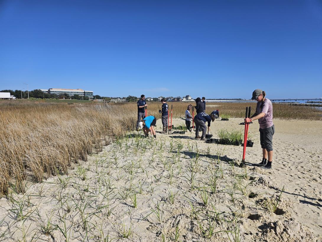
The islands were planted with 30,000 smooth cordgrass, grown at the DEP Nursery facility, during a substantial community volunteer effort with the help of local Boy Scout, Cub Scout and Girl Scout troops as well as numerous individuals and civic groups in September of 2007. Additional breakwater and salt marsh areas was constructed in the next few years under NRDA funding.
Ongoing Research
- Continuous Water Quality Monitoring: Northwest Florida Aquatic Preserves have conducted biannual seagrass monitoring at 25 fixed sites along the preserve since 2016. Water quality monitoring parameters include species composition, abundance, seagrass blade length, epiphytes, sediment type, temperature, salinity, water clarity, pH and dissolved oxygen.
Partner Groups
- National Park Service’s Gulf Islands National Seashore (GUIS).
- Ecosystem Restoration Support Organization: A nonprofit organization founded in 1999 by former restoration specialists and DEP employees. It helps Northwest Florida Aquatic Preserves with grant funding opportunities, as well as fundraising, ecotourism events and restoration project implementation.
- Aquatic Preserve Society: A statewide friends group for all aquatic preserves, was created in 2014 and Northwest Florida Aquatic Preserves may also participate or receive support from this group.
For the past five years, Northwest Florida Aquatic Preserve has been working on a grant funded by Deepwater Horizon Program’s Natural Resource Damage Assessment (NRDA) to add additional plantings of native vegetation to the islands at Project GreenShores II, place informational signage, remove invasive species and debris, and conduct monitoring.
Recently NWFLAP staff participated in the 32nd annual Day of Caring Event organized by United Way of Northwest Florida. We hosted a group of volunteers to help us with our first planting event of the season! On Day of Caring, 68 projects and 713 volunteers came together across two counties to make an impact in our local community. We partnered once again with Pensacola Energy to kick off planting season on the islands of Project Greenshores.
Through the Pensacola and Perdido Bay Estuary Program’s Collaborative Science to Assess Restoration Success (C-STARS) project, our team has been investigating the relationship between living shorelines and seagrasses. At one site, Project GreenShores (PGS), a large-scale living shoreline site in downtown Pensacola, 2 different species of seagrasses (Halodule wrightii and Ruppia maritima) have been confirmed, but not mapped.